


PPM Commander - GPS status

وصف لـPPM Commander - GPS status
Connect your external GPS device by USB or bluetooth. Route the GPS position as mock location provider to any navigation app on your phone or tablet.
Show GPS status data like position, height, accuracy, satellites, velocity, etc.
You can forward RTK correction data to your high accuracy external device. RTCM data is loaded from the internet by the internal NTRIP client.
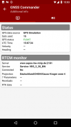
The app ist completely free with the exception of the NTRIP-RTCM feature. If you want to forward RTK data from your data provider (e.g. land surveying office) to the external GPS antenna, please license the app. You can fully test the NTRIP feature in advance within the 30 days trial period. You can view received RTCM message-types and coordinate-projection-parameters of the RTK data on the RTCM monitor page.
PPM Commander supports devices from ppm GmbH only, eg. ppm-10xx!
The PPM Commander can transform WGS84 coordinates into a local coordinate system like "Gauß-Krueger or UTM" for germany. Additionally you can set a fixed offset to the transformation for further improvement of the calculated local coordinate. If you allow mock locations in the developer options of your android device you can use the position of the external receiver in any application. The preferred way to process the external GPS position in other apps without using "mock locations" is implementing a simple ContentObserver. You can even get the transformed local coordinate and additional informations about the GPS status by using the app as content-provider.
By activating the "mocking" feature (get the position of your external GPS antenna into android) you can use this app for any other navigation-app or for geo-tagging.
Free features
+ GPS Status
+ Satellite list & Sky-Plot with subsystems like GPS, Glonass or Galileo
+ Coordinate-Transformation into local coordinate system
+ Mock location provider (e.g. use your external device for navigation)
+ Log all received NMEA data
You need a license for
+ RTK correction data over internet (NTRIP client)
+ RTCM monitor
+ Android "content provider" feature to access all status data
قم بتوصيل جهاز GPS خارجي بواسطة USB أو bluetooth . قم بتوجيه موضع GPS كـ موفر موقع وهمي إلى أي تطبيق تنقل على هاتفك أو جهازك اللوحي.
عرض بيانات حالة GPS مثل الموضع والارتفاع والدقة والأقمار الصناعية والسرعة وما إلى ذلك.
يمكنك إعادة توجيه بيانات تصحيح RTK إلى جهازك الخارجي عالي الدقة. يتم تحميل بيانات RTCM من الإنترنت بواسطة عميل NTRIP الداخلي.
التطبيق مجاني تمامًا باستثناء ميزة NTRIP-RTCM. إذا كنت ترغب في إعادة توجيه بيانات RTK من مزود البيانات (مثل مكتب مسح الأراضي) إلى هوائي GPS خارجي ، فالرجاء ترخيص التطبيق. يمكنك اختبار ميزة NTRIP بشكل كامل مقدمًا خلال فترة تجريبية مدتها 30 يومًا. يمكنك عرض أنواع رسائل RTCM المستلمة ومعلمات إحداثيات الإسقاط لبيانات RTK على صفحة مراقبة RTCM.
يدعم PPM Commander الأجهزة من ppm GmbH فقط ، على سبيل المثال. جزء في المليون-10xx!
يمكن لقائد PPM تحويل إحداثيات WGS84 إلى نظام إحداثيات محلي مثل "Gauß-Krueger أو UTM" من أجل ألمانيا. بالإضافة إلى ذلك ، يمكنك تعيين إزاحة ثابتة للتحويل لمزيد من التحسين للإحداثيات المحلية المحسوبة. إذا سمحت لمواقع وهمية في خيارات مطور جهاز Android الخاص بك ، فيمكنك استخدام موقع جهاز الاستقبال الخارجي في أي تطبيق. تتمثل الطريقة المفضلة لمعالجة موضع GPS الخارجي في تطبيقات أخرى دون استخدام "مواقع وهمية" في تطبيق ContentObserver البسيط. يمكنك حتى الحصول على الإحداثيات المحلية المحولة ومعلومات إضافية حول حالة GPS باستخدام التطبيق كموفر محتوى.
عن طريق تنشيط ميزة "الاستهزاء" (الحصول على موضع هوائي GPS الخارجي الخاص بك في android) ، يمكنك استخدام هذا التطبيق لأي تطبيق تنقل آخر أو لوضع علامات جغرافية.
ميزات مجانية
+ حالة GPS
+ قائمة الأقمار الصناعية و Sky-Plot مع الأنظمة الفرعية مثل GPS ، Glonass أو Galileo
+ تنسيق التحول إلى نظام الإحداثيات المحلي
+ مزود موقع وهمية (على سبيل المثال استخدام جهازك الخارجي للتنقل)
+ سجل جميع البيانات الواردة NMEA
أنت بحاجة إلى ترخيص لـ
+ بيانات تصحيح RTK عبر الإنترنت (عميل NTRIP)
+ رصد RTCM
+ ميزة "مزود المحتوى" في Android للوصول إلى جميع بيانات الحالة
PPM Commander - GPS status - إصدار 2.8.2.3
(13-06-2021)
PPM Commander - GPS status - معلومات APK
نُسخة APK: 2.8.2.3الحزمة: de.pilablu.gnsscommanderآخر إصدار من PPM Commander - GPS status
نُسخ أخرى


 3.78
3.78


تطبيقات من الفئة نفسها
قد يعجبك أيضًا...
 4.013.333.43
 4.063.62


